
The geodesic interpretation of fractal mechanics aims to explain the processes of measuring, modeling, and positioning the Earth through fractal regularities and multi-scale motifs. Classically, geodesy works with geometric measurements and coordinate systems; the fractal approach, however, reveals the self-similarity and scale-independent order dimension behind these measurements.
Basic Dimensions
- Fractal Structure of Terrain Surfaces
- Mountains, hills, plains, and coastlines can be defined by fractal dimension.
- Surface roughness is modeled with a fractal roughness coefficient instead of classical planar measurement.
- This approach enables a more precise interpretation of data obtained from satellite imagery.
- Coordinate Systems and Fractal Space
- Coordinates used in geodesy (lat/long, UTM) can be expanded with the fractal space-time interpretation of fractal mechanics.
- Positioning errors are explained by fractal fluctuation functions.
- Deviations in GPS signals can be corrected more accurately with fractal noise models.
- Gravity and Geopotential Fields
- The Earth’s gravity field can be modeled with fractal energy functions instead of classical geopotential surfaces.
- Small-scale anomalies (e.g., mineral deposits, underground cavities) are revealed more clearly through fractal fluctuation motifs.
- Geodetic Measurement Technologies
- Laser scanning (LiDAR), radar interferometry, and satellite altimetry data can be processed with fractal filters.
- In this way, measurement errors are reduced, and multi-scale surface models are obtained.
Comparative Table
| Geodesy Area | Fractal Mechanics Interpretation | Result / Contribution |
| Terrain Surfaces | Fractal dimension and roughness coefficient | More precise surface modeling |
| Coordinates | Fractal space-time and fluctuation functions | Fractal correction of GPS errors |
| Gravity Field | Fractal energy functions | Detection of small-scale anomalies |
| Measurement Tech. | Fractal filtering and multi-scale analysis | More accurate and scale-independent measurement |
In summary, the geodesic interpretation of fractal mechanics is a paradigm that redefines the measurement of the Earth through scale-independent regularities and fractal motifs. In addition to classical geodetic measurements, this approach provides deeper accuracy with fractal dimension, fractal energy functions, and fractal noise models.
Fractal Structure of Terrain Surfaces
The fractal structure of terrain surfaces goes beyond classical planar or curved surface definitions in geodesy, making it possible to explain the roughness and complexity in nature in a scale-independent manner.
Properties of Fractal Surfaces
- Self-similarity: Mountain ranges, coastlines, and valleys show similar patterns at different scales. The form of a small hill can be a miniature version of the form of a large mountain.
- Fractal dimension: Unlike a classical 2D plane, surfaces are defined by fractional dimensions. For example, a mountain surface might have a dimension like D = 2.2; this indicates that the surface is not flat, but rough and complex.
- Roughness coefficient: Measures how jagged the terrain surface is. This coefficient reduces the margin of error in geodetic measurements.
- Multi-scale analysis: When data obtained from satellite images are examined at different resolutions, the fractal structure of the surface is revealed.
Classical vs Fractal Surface Model
| Criterion | Classical Geodesy | Fractal Geodesy |
| Surface Definition | Plane or curved surface | Rough, fractional dimensional surface |
| Scale | Single-scale | Multi-scale, scale-independent |
| Complexity | Simple, regular | Infinite detail, irregular |
| Nature Alignment | Approximate model | Closer to true surface structure |
Application Areas
- Satellite altimetry: Defines the undulating structure of ocean and land surfaces with fractal dimension.
- LiDAR scanning: Measures the roughness of forest and city surfaces on a multi-scale basis.
- Geological mapping: Reveals the fractal motifs of fault lines and mountain formations.
The fractal structure of terrain surfaces provides scale-independent accuracy in geodesy. Through this approach, the roughness and complexity overlooked by classical planar models become directly measurable.
Coordinate Systems and Fractal Space
The interpretation of coordinate systems and fractal space aims to mathematically express the multi-scale and self-similar structure of nature by overcoming the linear and fixed-scale coordinate definitions of classical geodesy.
Basic Features of Fractal Coordinate Systems
- Fractional Dimensional Position: Points are defined not only by x, y, z, but also by the fractal dimension D. This includes the degree of roughness and complexity of the position.
- Fractal Space-Time: Classical coordinates depend on a constant flow of time; the space-time interpretation of fractal mechanics accepts that time also has multi-scale fluctuations. GPS errors or signal shifts can be modeled with these fluctuation functions.
- Fluctuation Functions: Deviations in position measurements are explained by fractal noise functions. This allows measurement errors to be corrected independent of scale.
- Multi-Scale Positioning: The coordinate of a point is defined not just at a single resolution, but at different scales. A fractal transformation can be made between satellite data and ground measurement.
Classical vs Fractal Coordinate System
| Criterion | Classical System | Fractal System |
| Dimension | 2D/3D fixed | Fractional, multi-scale |
| Time | Linear flow | Fractal fluctuation |
| Error Model | Statistical deviation | Fractal noise function |
| Position Definition | Single-scale point | Multi-scale, self-similar point |
Application Areas
- GPS corrections: Signal deviations are reduced with fractal noise models.
- Satellite geodesy: High-resolution satellite data are interpreted more accurately with multi-scale coordinate systems.
- Urban planning: Complex city structures are modeled with fractal coordinates to optimize infrastructure arrangements.
- Geological analysis: Fault lines and underground cavities are positioned more precisely in fractal space.
In summary, fractal coordinate systems mathematically capture the scale-independent complexity of nature. Going beyond classical geodetic coordinates, this approach both increases positional accuracy and allows for the explanation of multi-scale processes.
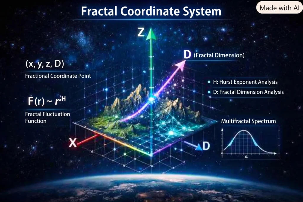
The visualized state of the fractal coordinate system is above. In this visual, in addition to the classical x, y, z axes, there is a fractal dimension axis D. Thus, coordinates include not only position but also the fractional dimensional complexity of nature.
Such a system provides scale-independent accuracy by integrating fluctuation functions (𝐹(𝑟) ∼ 𝑟H) directly into coordinates in applications like GPS and satellite geodesy. The visual also includes the multifractal spectrum curve and Hurst exponent analysis; these are critical parameters in the mathematical solution of fluctuations.
Gravity and Fractal Geopotential
The interpretation of gravity and fractal geopotential goes beyond classical Newton and geodesy models, aiming to explain the Earth’s mass distribution and gravitational field through multi-scale, self-similar fluctuations.
Basic Principles of Fractal Geopotential
- Fractional Potential Functions: The gravity field is defined by functions containing the fractal dimension D, unlike the classical formula 𝑉 =−𝐺𝑀/𝑟. This reflects the rough and scale-independent structure of the field.
- Multi-Scale Fluctuations: The gravity field consists not only of spherical but also of regional and local fractal fluctuations. Mineral deposits, underground cavities, or mountain ranges are examples of these fluctuations.
- Fractal Noise and Anomalies: Small deviations seen in measurements are interpreted as fractal noise, not statistical error. This approach ensures more accurate detection of anomalies.
- Energy Functions: Geopotential surfaces are modeled with fractal energy functions. These functions reinterpret the classical geoid definition as a multi-scale energy surface.
Classical vs Fractal Geopotential
| Criterion | Classical Model | Fractal Model |
| Potential Definition | Newton/Poisson equations | Fractional dimensional functions |
| Field Structure | Spherical, smooth | Multi-scale, undulating |
| Anomalies | Statistical deviation | Fractal noise |
| Geoid | Single surface | Multi-scale energy surface |
Application Areas
- Satellite gravimetry: Measures the Earth’s mass distribution more precisely with fractal energy functions.
- Geological exploration: Underground minerals and cavities are detected with fractal anomalies.
- Earthquake analysis: Gravity fluctuations of fault lines are explained with a fractal model.
- Cosmology connection: Fractal geopotential on an Earth scale can be associated with universal fractal gravity models.
In summary, the fractal geopotential approach defines gravity as a scale-independent, fractional dimensional, and undulating energy field. This provides a more precise and realistic explanation beyond classical models in both geodesy and geology.
Fractal Geodetic Measurement Technologies
Fractal geodetic measurement technologies deepen the accuracy offered by classical measuring instruments with multi-scale fractal filtering and self-similarity analysis. This approach reduces measurement errors while revealing the true complexity of surfaces.
Basic Technologies
- LiDAR scanning: Surface scanning is performed with laser beams. Thanks to fractal filtering, the roughness of forest, city, and mountain surfaces is measured on a multi-scale basis.
- Radar interferometry: Surface deformations are measured using the phase difference between two radar signals. Small-scale movements are detected more clearly with fractal fluctuation functions.
- Satellite altimetry: Elevation data of ocean and land surfaces are processed with fractal dimension analysis. Undulating structures are defined independent of scale, unlike classical smoothing.
- GNSS/GPS measurements: Positioning errors are corrected with fractal noise models. This ensures centimeter-level precision.
Classical vs Fractal Measurement Technologies
| Technology | Classical Use | Fractal Interpretation |
| LiDAR | Surface scanning | Multi-scale roughness analysis |
| Radar Interferometry | Deformation measurement | Fractal fluctuation detection |
| Satellite Altimetry | Elevation measurement | Fractal dimensional surface model |
| GPS | Positioning | Fractal noise correction |
Application Areas
- Disaster management: Post-earthquake surface deformations are measured more precisely with fractal radar models.
- Urban planning: Surface roughness is taken into account in infrastructure arrangements.
- Geological exploration: Mineral deposits and underground cavities are detected with fractal anomalies.
- Oceanography: Wave and current models are extracted more accurately with fractal altimeter data.
In summary, fractal geodetic measurement technologies provide scale-independent accuracy and reveal the complex surface structure overlooked by classical measurement methods.
Fractional Dimensional Coordinates
Fractional dimensional coordinates are one of the most radical interpretations that fractal mechanics brings to geodesy. While in classical coordinate systems a point is defined only by (x, y, z), in the fractal approach, the fractal dimension of this point is also added to the coordinate definition. Thus, the position is expressed not only geometrically but also with its degree of roughness and complexity.
Basic Principles
- Fractal dimension parameter: The coordinates of a point are defined in the format (x, y, z, D). Here, D is the fractional dimension and indicates the fractal structure of the surface.
- Fractional coordinate transformation: The transition from classical coordinates to fractal coordinates is done using methods like box-counting or the Hurst exponent.
- Multi-scale positioning: A point can take different fractal dimension values at different resolutions. This provides a transformation between satellite and ground measurements.
- Fractal fluctuation functions: Deviations in GPS and GNSS measurements are modeled as fractal noise in the fractional coordinate system.
Classical vs Fractional Coordinates
| Criterion | Classical System | Fractional Fractal System |
| Point Definition | (x, y, z) | (x, y, z, D) |
| Dimension | Integer (2D/3D) | Fractional, multi-scale |
| Error Model | Statistical deviation | Fractal noise |
| Nature Alignment | Approximate | Scale-independent, realistic |
Application Areas
- GPS corrections: Positioning errors are minimized with the fractal dimension parameter.
- Satellite geodesy: High-resolution satellite data are modeled more accurately with fractional coordinates.
- Geological exploration: Underground cavities and mineral deposits are detected by fractal coordinate anomalies.
- Urban planning: Complex city structures are optimized with fractional coordinate systems.
In summary, fractional dimensional coordinates directly integrate the scale-independent complexity of nature into the coordinate system. By moving beyond classical linear models in geodesy, this both increases positional accuracy and reflects the true structure of surfaces more accurately.
Fractal Space-Time Model
The fractal space-time model transforms the concept of a continuous and smooth manifold in classical relativity into a framework that reflects the multi-scale and self-similar structure of nature. In this model, space and time are defined not only by coordinate axes but also by fractal dimensions and fluctuation functions.
Basic Principles
- Fractional dimensional space: Spatial coordinates (x, y, z) are 3-dimensional in the classical sense; in the fractal model, this dimension can be fractional (𝐷 = 3 + 𝛿). This shows the rough and scale-independent structure of space.
- Fractal flow of time: Time is not a linear flow but is defined by fractal fluctuations. This is compatible with quantum uncertainties at the microscopic scale and cosmic processes at the macroscopic scale.
- Fractal metric tensor: The metric tensor gμv in relativity is expanded with scale-dependent functions in the fractal model. Thus, geodesics (shortest paths) are redefined according to fractal fluctuations.
- Energy and geopotential connection: Gravity fields are modeled with fractal energy functions; this is directly related to the fractal geopotential approach in geodesy.
Classical vs Fractal Space-Time
| Criterion | Classical Relativity | Fractal Model |
| Space Dimension | 3D fixed | Fractional, scale-dependent |
| Time | Linear flow | Fractal fluctuation |
| Metric | Smooth manifold | Fractal metric tensor |
| Geodesic | Shortest path | Multi-scale fractal path |
Application Areas
- Quantum-gravity: Fractal space-time forms the basis for a unified model between quantum mechanics and relativity.
- Geodesy: Time deviations in GPS and satellite measurements are explained by fractal fluctuation functions.
- Cosmology: The large-scale structure of the universe (galaxy clusters, cosmic web) is defined in compatibility with the fractal space-time model.
- Energy distribution: Gravity anomalies and geopotential surfaces are modeled with fractal energy functions.
In summary, the fractal space-time model defines nature as a fractional dimensional, scale-independent, and fluctuating manifold. This approach presents a new paradigm for both geodesy and quantum-gravity.
Multi-Scale Positioning
Multi-scale positioning is one of the most powerful applications of fractal geodesy. While a point is measured at a single resolution in classical geodesy, the same point is redefined at different scales in the fractal approach. This makes it possible to combine both satellite and ground measurements in a common fractal coordinate system.
Basic Principles
- Scale-independent definition: The position of a point is defined not just at a single resolution, but at different scales simultaneously.
- Fractal coordinate transformation: A fractal transformation is made between satellite data (macro scale) and ground measurement (micro scale).
- Fractional dimension parameter: The position is defined in the format (x, y, z, D); D is the fractal dimension and indicates the complexity of the surface.
- Fluctuation functions: Deviations in GPS and GNSS measurements are modeled with fractal fluctuation functions to ensure coherence across scales.
Classical vs Multi-Scale Positioning
| Criterion | Classical System | Fractal Multi-Scale System |
| Position Definition | Point at a single resolution | Same point at different scales |
| Scale Compatibility | Discrete measurements | Transformation across scales |
| Error Model | Statistical deviation | Fractal fluctuation |
| Nature Alignment | Approximate | Scale-independent, realistic |
Application Areas
- GPS corrections: Positional errors are minimized with fractal transformation at different scales.
- Satellite geodesy: High-resolution satellite data are aligned with ground measurements.
- Geological exploration: Underground cavities and mineral deposits are detected more precisely with multi-scale positioning.
- Urban planning: Surface data at different scales are evaluated together in infrastructure arrangements.
In summary, multi-scale positioning directly integrates cross-scale continuity in nature into the coordinate system. In this way, the accurate definition of the same point is made at both micro and macro scales.
Fractal Coordinate Transformation
Fractal coordinate transformation is the redefinition of fixed-scale coordinates used in classical geodetic systems in a way that reflects the multi-scale and self-similar structure of nature. This transformation allows satellite data and ground measurements to be combined in the same fractal framework.
Basic Principles
- Fractional coordinate definition: Points are defined in the format (x, y, z, D); D is the fractal dimension and indicates the complexity of the surface.
- Box-counting method: Surface or position data is divided into boxes at different scales to calculate the fractal dimension. This dimension is added to the coordinate system.
- Hurst exponent transformation: Fluctuations in time series are scaled by the Hurst exponent. This parameter is added to the time dimension in the coordinate transformation.
- Multifractal spectrum: Instead of a single fractal dimension, different dimensions are used at different scales. This makes the coordinate transformation more realistic.
Classical vs Fractal Coordinate Transformation
| Criterion | Classical System | Fractal Transformation |
| Point Definition | (x, y, z) | (x, y, z, D) |
| Scale | Single-scale | Multi-scale |
| Error Model | Statistical deviation | Fractal fluctuation |
| Nature Alignment | Approximate | Scale-independent, realistic |
Application Areas
- GPS corrections: Positional errors are minimized with fractal transformation.
- Satellite geodesy: Satellite data are aligned with ground measurements.
- Geological exploration: Underground cavities and mineral deposits are detected by fractal coordinate anomalies.
- Urban planning: Complex city structures are optimized with fractal coordinate transformation.
In summary, fractal coordinate transformation directly integrates cross-scale continuity in nature into the coordinate system. In this way, the accurate definition of the same point is made at both micro and macro scales.
Fractal Coordinate Transformation GPS
In the context of GPS, fractal coordinate transformation aims to correct the deviations seen in classical positioning systems with the multi-scale structure of fractal mechanics. GPS measurements exhibit fluctuations due to atmospheric effects, signal reflections, and device errors. Fractal transformation redefines these fluctuations with scale-independent fractal functions.
Basic Principles
- Fractional coordinate definition: GPS points are defined in the format (x, y, z, D); D is the fractal dimension and indicates the complexity of the signal.
- Fractal fluctuation functions: Deviations in the GPS signal are modeled as fractal noise, not statistical error. In this way, errors can be corrected independently of scale.
- Hurst exponent analysis: GPS time series are analyzed with the Hurst exponent. The H value determines the degree of continuity or randomness of the signal.
- Multifractal transformation: Instead of a single fractal dimension, different dimensions are used at different scales. This allows for a more realistic interpretation of GPS data.
Classical vs Fractal GPS Transformation
| Criterion | Classical GPS | Fractal GPS Transformation |
| Position Definition | (x, y, z) | (x, y, z, D) |
| Error Model | Statistical deviation | Fractal fluctuation |
| Time Series | Linear | Fractal fluctuating |
| Nature Alignment | Approximate | Scale-independent, realistic |
Application Areas
- High-precision geodesy: Centimeter-level positional accuracy is achieved.
- Disaster management: Post-earthquake surface deformations are measured more precisely with fractal GPS transformation.
- Urban planning: GPS data is optimized with fractal transformation in infrastructure arrangements.
- Geological exploration: Underground cavities and mineral deposits are detected by GPS anomalies.
In summary, fractal coordinate transformation redefines GPS data within a scale-independent, fractional dimensional, and fluctuating system. This approach overcomes the limited accuracy of classical GPS, providing more precise positioning at both micro and macro scales.
Fractal Fluctuation Functions
Fractal fluctuation functions are mathematical tools that interpret deviations in natural measurement data not as classical statistical errors, but as a part of scale-independent order. These functions lie at the core of both geodesy and fractal mechanics.
Basic Features
- Self-similar fluctuations: Fluctuation functions repeat the same motifs at different scales. Small deviations are miniature versions of large-scale fluctuations.
- Fractional dimension parameter: Fluctuations are defined not only by amplitude and frequency but also by the fractal dimension D. This measures the degree of complexity of the fluctuation.
- Hurst exponent connection: Fluctuation functions are generally associated with the Hurst exponent H. The H value determines the degree of continuity or randomness of the fluctuation.
- Multifractal spectrum: Instead of a single fractal dimension, it can show different dimensions at different scales. This reveals the multifractal structure of the fluctuation.
Classical vs Fractal Fluctuation Interpretation
| Criterion | Classical Model | Fractal Model |
| Deviation Definition | Statistical error | Scale-independent fluctuation |
| Parameters | Mean, variance | Fractal dimension, Hurst exponent |
| Structure | Irregular, random | Self-similar, multi-scale |
| Application | Error correction | Analysis of natural structure |
Application Areas
- GPS and GNSS measurements: Positional errors are modeled with fractal fluctuation functions.
- Satellite geodesy: Deviations in elevation and surface data are interpreted as fractal fluctuations.
- Geological analysis: Fault lines and underground cavities are detected with fluctuation functions.
- Cosmology: Galaxy distributions and the cosmic web structure are explained by fractal fluctuation functions.
In summary, fractal fluctuation functions view deviations in nature not as errors, but as a part of order. This approach provides a more realistic and scale-independent model for both geodesy and physics.
Fractal Fluctuation Mathematical Formulations
The mathematical formulation of fractal fluctuation functions defines deviations in nature as a part of scale-independent order rather than classical statistical error. This formulation forms the foundation of both geodesy and fractal mechanics.
Basic Mathematical Structures
- Basic fractal function: Fluctuation amplitude is expressed with scale as follows: 𝐹(𝑟) ∼ 𝑟
𝐻. Here, r is the scale (distance), and H is the Hurst exponent. - Fractional dimension connection: Fractal dimension D is related to the fluctuation function: D = E + 1 – H. Here, $E$ is the dimension of the embedding space (e.g., E = 2 for a surface).
- Covariance function: The correlation of fluctuations is defined as: 𝐶(𝜏) ∼ 𝜏2𝐻. This indicates fractal dependence in time series.
- Multifractal spectrum: Instead of a single dimension, different dimensions are used at different scales: 𝑓(𝛼) = 𝑞𝛼 − 𝜏(𝑞). Here, α is the local fractal dimension, and τ(q) is the moment function.
Classical vs Fractal Formulation
| Criterion | Classical Model | Fractal Model |
| Deviation Definition | Mean ± variance | Scale-independent function |
| Parameters | Standard deviation | Hurst exponent, fractal dimension |
| Structure | Random | Self-similar, multi-scale |
| Spectrum | Single dimension | Multifractal spectrum |
Application Areas
- GPS error correction: Positional deviations are modeled with the 𝐹(𝑟) ∼ 𝑟
𝐻function. - Satellite geodesy: Fluctuations in elevation data are explained by the multifractal spectrum.
- Geological analysis: Fault lines and underground cavities are detected with fractal covariance functions.
- Cosmology: Galaxy distributions are modeled with the multifractal spectrum.
In summary, the mathematical formulation of fractal fluctuation functions defines deviations in nature as scale-independent, fractional dimensional, and multifractal structures. This approach provides a more realistic model for both geodesy and physics.